| |
Location |
Freq. |
Tone |
Lat. – Long. |
Antenna Height |
Callsign |
Link |
| |
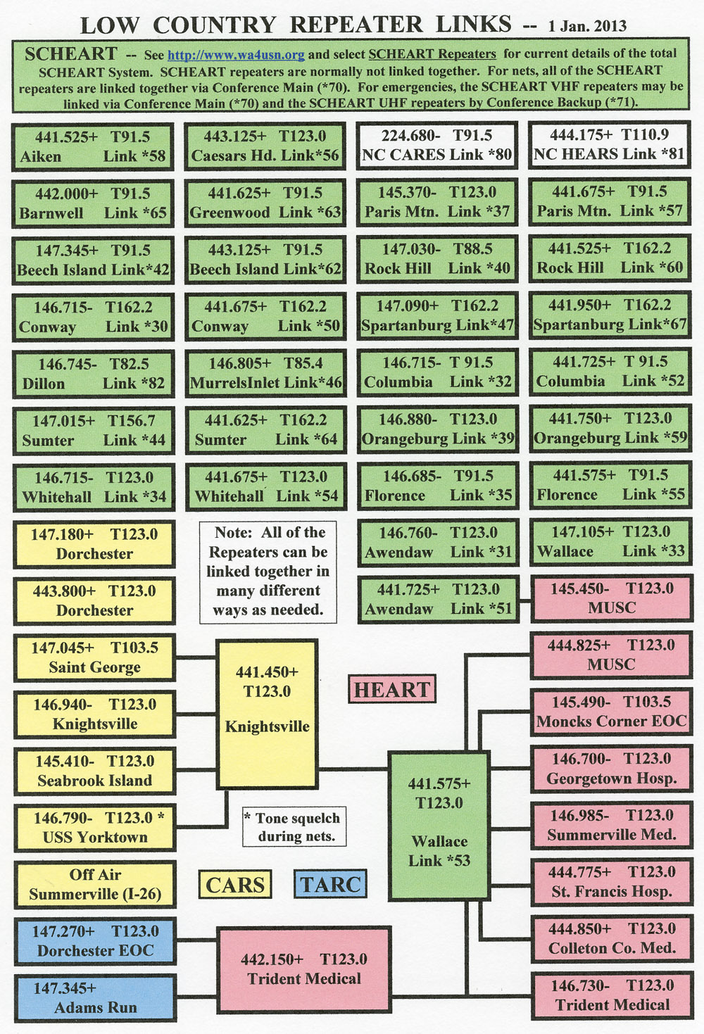
Adams Run |
147.345+ |
141.3 |
N 32° 43′ 4″ W 80° 18′ 49″ |
|
K4IUG |
T |
| |
Awendaw (Chan. 5 Tower) |
146.760- |
123.0 |
N 32° 55′ 28″ W 79° 41′ 58″ |
855 |
WR4SC |
Link *31 |
| |
Awendaw (Chan. 5 Tower) |
441.725+ |
123.0 |
N 32° 55′ 28″ W 79° 41′ 58″ |
950 |
WR4SC |
Link *51 H |
| |
Colleton County Medical |
444.850+ |
123.0 |
N 32° 55′ 19″ W 80° 40′ 30″ |
60 |
W4HRS |
W |
| |
Columbia (I-77 & I-20) |
146.715- |
91.5 |
N 34° 07′ 07″ W 80° 56′ 13″ |
825 |
WR4SC |
Link *32 |
| |
Columbia (I-77 & I-20) |
441.725+ |
91.5 |
N 34° 07′ 07″ W 80° 56′ 13″ |
800 |
WR4SC |
Link *52 H |
| |
Conway (SCETV Tower) |
146.715- |
162.2 |
N 33° 56′ 59″ W 79° 06′ 31″ |
480 |
WR4SC |
Link *30 |
| |
Conway (SCETV Tower) |
441.675+ |
162.2 |
N 33° 56′ 59″ W 79° 06′ 31″ |
500 |
WR4SC |
Link *50 H |
| |
Dorchester |
147.180+ |
123.0 |
N 33° 08′ 31″ W 80° 21′ 03″ |
280 |
W4HNK |
|
| |
Dorchester |
443.800+ |
123.0 |
N 33° 08′ 31″ W 80° 21′ 03″ |
|
W4HNK |
|
| |
Florence (SCETV Tower) |
146.685- |
91.5 |
N 34° 16′ 48″ W 79° 44′ 34″ |
480 |
WR4SC |
Link *35 |
| |
Florence |
147.195+ |
123.0 |
|
|
W4APE |
P |
| |
Florence (SCETV Tower) |
441.575+ |
91.5 |
N 34° 16′ 48″ W 79° 44′ 34″ |
500 |
WR4SC |
Link *55 H |
| |
Florence |
442.050+ |
123.0 |
|
|
W4APE |
H P |
| |
Georgetown Mem. Hospital |
146.700- |
123.0 |
N 33° 22′ 46″ W 79° 17′ 05″ |
60 |
W4HRS |
W |
| |
Georgetown |
147.375+ |
123.0 |
|
|
NE4SC |
|
| |
Georgetown |
444.925+ |
123.0 |
|
|
NE4SC |
|
| |
Goose Creek |
146.610- |
123.0 |
N 33° 07′ 32″ W 80° 02′ 20″ |
450 |
W4BRK |
|
| |
Greeleyville |
145.230- |
123.0 |
|
|
W4APE |
P |
| |
Greeleyville |
444.750+ |
123.0 |
|
|
W4APE |
P |
| |
Knightsville |
146.940- |
123.0 |
N 32° 59′ 38″ W 80° 16′ 12″ |
280 |
WA4USN |
K |
| |
Knightsville |
441.450+ |
123.0 |
N 32° 59′ 38″ W 80° 16′ 12″ |
260 |
WA4USN |
H K A |
| |
Moncks Corner EOC |
145.490- |
103.5 |
N 33° 11′ 56″ W 80° 00′ 25″ |
150 |
W4HRS |
W |
| |
Moncks Corner |
147.150+ |
91.5 |
N 33° 11′ 56″ W 80° 00′ 25″ |
150 |
WD4NUN |
|
| |
Moncks Corner |
147.210+ |
210.7 |
|
|
|
|
| |
Orangeburg |
146.880- |
123.0 |
N 33° 32′ 35″ W 80° 49′ 27″ |
380 |
WR4SC |
Link *39 |
| |
Orangeburg |
441.750+ |
123.0 |
N 33° 32′ 35″ W 80° 49′ 27″ |
400 |
WR4SC |
Link *59 H |
| |
Russellville |
147.300+ |
162.2 |
|
|
|
|
| |
Rutledge Tower (MUSC) |
145.450- |
123.0 |
N 32° 47′ 03″ W 79° 56′ 42″ |
160 |
W4HRS |
T |
| |
Rutledge Tower (MUSC) |
444.825+ |
123.0 |
N 32° 47′ 03″ W 79° 56′ 42″ |
160 |
W4HRS |
W |
| |
St. Francis Hospital |
444.775+ |
123.0 |
N 32° 48′ 30″ W 80° 02′ 31″ |
40 |
W4HRS |
W |
| |
St. George |
147.045+ |
103.5 |
N 33° 10′ 25″ W 80° 34′ 26″ |
|
K4ILT |
K |
| |
Santee |
147.225+ |
None |
|
|
W4DTW |
|
| |
Seabrook Island |
145.410- |
123.0 |
N 32° 34′ 50″ W 80° 09′ 35″ |
150 |
WA4USN |
K |
| |
S’ville (OFF AIR) |
147.270+ |
123.0 |
|
|
W4ANK |
T |
| Off Air |
Summerville (I-26) |
146.835- |
None |
N 33° 02′ 20″ W 80° 09′ 16″ |
|
KT4YW |
|
| |
Summerville Med. Center |
146.985- |
123.0 |
N 32° 57′ 57″ W 80° 09′ 27″ |
65 |
W1GRE |
W |
| |
Trident Medical Center |
146.730- |
123.0 |
N 32° 58′ 35″ W 80° 04′ 24″ |
94 |
W4HRS |
W |
| |
Trident Medical Center |
442.150+ |
123.0 |
N 32° 58′ 35″ W 80° 04′ 24″ |
94 |
W4HRS |
H T |
| Tone 4 Nets |
USS Yorktown |
146.790- |
123.0 |
N 32° 47′ 26″ W 79° 54′ 29″ |
|
WA4USN |
K |
| |
Wallace (SCETV Tower) |
147.105+ |
123.0 |
N 32° 48′ 08″ W 80° 01′ 25″ |
380 |
WR4SC |
Link *33 |
| |
Wallace (SCETV Tower) |
441.575+ |
123.0 |
N 32° 48′ 08″ W 80° 01′ 25″ |
400 |
WR4SC |
Link *53 H |
| |
Walterboro |
145.390- |
None |
|
|
KG4BZN |
L |
| |
Walterboro |
147.135+ |
156.7 |
|
|
KG4BZN |
L |
| |
Walterboro |
444.550+ |
156.7 |
|
|
KG4BZN |
L |
| |
Whitehall (SCETV Tower) |
146.715- |
123.0 |
N 32° 42′ 43″ W 80° 40′ 54″ |
835 |
WR4SC |
Link *34 |
| |
Whitehall (SCETV Tower) |
146.910- |
156.7 |
N 32° 42′ 43″ W 80° 40′ 54″ |
|
WA4SJS |
L |
| |
Whitehall (SCETV Tower) |
441.675+ |
123.0 |
N 32° 42′ 43″ W 80° 40′ 54″ |
815 |
WR4SC |
Link *54 H |
| |
Whitehall (SCETV Tower) |
444.075+ |
156.7 |
N 32° 42′ 43″ W 80° 40′ 54″ |
|
KG4BZN |
H L |
Recent Comments